TopoQuest Logo
Do you find TopoQuest useful?
Help keep TopoQuest running and adding new maps/features by donating!
Bitcoin:  19c7KJd3qBynnjoSw5npx9KScwjBe4ifkT
Litecoin:  LXs6TkuXGGXo1vDsWCkWVdjQX94eUKd6ui
Home View Maps Find Maps Find Places Resources & Links


Swanson, Michigan Topographic Map

USGS Map Title: Swanson, MI
USGS Map MRC: 45087D6
DRG (GeoTIFF) Download: o45087d6.tif


Neighboring USGS Topographic Map Quads:


  Miscauno Island, WI  
45087E7
 

  Banat, MI  
45087E6
 

  Nadeau, MI  
45087E5
 

  Resort Lake, MI  
45087D7
 

  Swanson, MI  
45087D6
 

  Stephenson, MI  
45087D5
 

  Bear Point, MI  
45087C7
 

  McAllister, WI  
45087C6
 

  Wallace, MI  
45087C5


Map MRC Location:

N46°
W88°
N46°
W87°
H8 H7 H6 H5 H4 H3 H2 H1
G8 G7 G6 G5 G4 G3 G2 G1
F8 F7 F6 F5 F4 F3 F2 F1
E8 E7 E6 E5 E4 E3 E2 E1
D8 D7 D6 D5 D4 D3 D2 D1
C8 C7 C6 C5 C4 C3 C2 C1
B8 B7 B6 B5 B4 B3 B2 B1
A8 A7 A6 A5 A4 A3 A2 A1
N45°
W88°
N45°
W87°

Swanson, MI USGS 1:24K Topographic Map Preview:
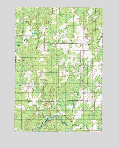
Swanson, MI USGS Topographic Map
Click on map above to begin viewing in our Map Viewer.

This topographic map contains these locations and features:
Feature Name Type Latitude Longitude GNIS ID View Map
Ash LakeLakeN45.4762°W87.7225°620266View Map
Bethesda ChurchChurchN45.4636°W87.6479°621230View Map
Bethesda Lutheran CemeteryCemeteryN45.4633°W87.6467°2353264View Map
Central Baptist ChurchChurchN45.4211°W87.6461°2353209View Map
Harding CreekStreamN45.4486°W87.6732°627767View Map
Johnson LakeLakeN45.4622°W87.7477°629341View Map
KellsPopulated PlaceN45.4344°W87.7090°1617654View Map
Kells Post Office (historical)Post OfficeN45.3844°W87.7089°2353167View Map
Kells Station (historical)LocaleN45.3844°W87.7264°2353166View Map
KossPopulated PlaceN45.3905°W87.7065°1617663View Map
Koss CreekStreamN45.3886°W87.7018°629861View Map
Koss Post Office (historical)Post OfficeN45.3906°W87.7064°2353165View Map
Koss Station (historical)LocaleN45.3903°W87.7064°2353164View Map
Linnbeck LakeLakeN45.4857°W87.7377°630518View Map
LongriePopulated PlaceN45.4058°W87.7251°1617688View Map
Longrie LakeLakeN45.4236°W87.7426°631015View Map
Longrie Station (historical)LocaleN45.4058°W87.7250°2352939View Map
Menominee County ParkParkN45.4067°W87.7289°2099840View Map
Phillips CreekStreamN45.3830°W87.6748°634759View Map
Star CornersLocaleN45.4641°W87.7084°638736View Map
SwansonPopulated PlaceN45.4747°W87.7087°1617885View Map
Swanson CreekStreamN45.4644°W87.7407°1614473View Map
Swanson LakeLakeN45.4737°W87.7254°1614474View Map
Swanson Post Office (historical)Post OfficeN45.4747°W87.7086°2353156View Map
Swanson Station (historical)LocaleN45.4750°W87.7106°2353155View Map
Swedish Methodist CemeteryCemeteryN45.4639°W87.6769°2353253View Map
Woods CreekStreamN45.3891°W87.6734°1616789View Map

Note: Coordinates in the location and feature list above are referenced to NAD83 datum.


Copyright (C) 2008-2025 Ryan Niemi / Sunset Dynamics ... All Rights Reserved