TopoQuest Logo
Do you find TopoQuest useful?
Help keep TopoQuest running and adding new maps/features by donating!
Bitcoin:  19c7KJd3qBynnjoSw5npx9KScwjBe4ifkT
Litecoin:  LXs6TkuXGGXo1vDsWCkWVdjQX94eUKd6ui
Home View Maps Find Maps Find Places Resources & Links


Banat, Michigan Topographic Map

USGS Map Title: Banat, MI
USGS Map MRC: 45087E6
DRG (GeoTIFF) Download: o45087e6.tif


Neighboring USGS Topographic Map Quads:


  Faithorn, MI  
45087F7
 

  Cunard, MI  
45087F6
 

  Hermansville, MI  
45087F5
 

  Miscauno Island, WI  
45087E7
 

  Banat, MI  
45087E6
 

  Nadeau, MI  
45087E5
 

  Resort Lake, MI  
45087D7
 

  Swanson, MI  
45087D6
 

  Stephenson, MI  
45087D5


Map MRC Location:

N46°
W88°
N46°
W87°
H8 H7 H6 H5 H4 H3 H2 H1
G8 G7 G6 G5 G4 G3 G2 G1
F8 F7 F6 F5 F4 F3 F2 F1
E8 E7 E6 E5 E4 E3 E2 E1
D8 D7 D6 D5 D4 D3 D2 D1
C8 C7 C6 C5 C4 C3 C2 C1
B8 B7 B6 B5 B4 B3 B2 B1
A8 A7 A6 A5 A4 A3 A2 A1
N45°
W88°
N45°
W87°

Banat, MI USGS 1:24K Topographic Map Preview:
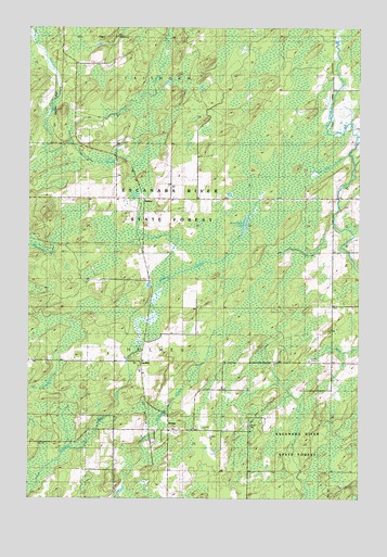
Banat, MI USGS Topographic Map
Click on map above to begin viewing in our Map Viewer.

This topographic map contains these locations and features:
Feature Name Type Latitude Longitude GNIS ID View Map
Arnold Station (historical)LocaleN45.5506°W87.7056°2352937View Map
BanatPopulated PlaceN45.5177°W87.6976°620537View Map
Banat Post Office (historical)Post OfficeN45.5178°W87.6975°2353185View Map
Banat Station (historical)LocaleN45.5181°W87.7042°2353184View Map
Blom CreekStreamN45.6230°W87.7476°621603View Map
Bog BrookStreamN45.5908°W87.6301°621682View Map
DeHaas CreekStreamN45.5947°W87.7348°624394View Map
GardnerPopulated PlaceN45.5364°W87.7079°1617576View Map
Gardner Station (historical)LocaleN45.5364°W87.7078°2352938View Map
Hammond BrookStreamN45.5925°W87.7457°627698View Map
Holy Rosary Catholic ChurchChurchN45.5150°W87.7028°2353258View Map
Holy Rosary Catholic Church CemeteryCemeteryN45.5147°W87.7025°2774393View Map
Laurin CreekStreamN45.5883°W87.6271°630195View Map
NathanPopulated PlaceN45.5791°W87.7071°1617736View Map
Nathan Post Office (historical)Post OfficeN45.5792°W87.7069°2353158View Map
Nathan Station (historical)LocaleN45.5792°W87.7075°2353159View Map
Township of HolmesCivilN45.5284°W87.7191°1626481View Map
Wire Grass LakeLakeN45.5728°W87.6684°1616654View Map

Note: Coordinates in the location and feature list above are referenced to NAD83 datum.


Copyright (C) 2008-2025 Ryan Niemi / Sunset Dynamics ... All Rights Reserved