TopoQuest Logo
Do you find TopoQuest useful?
Help keep TopoQuest running and adding new maps/features by donating!
Bitcoin:  19c7KJd3qBynnjoSw5npx9KScwjBe4ifkT
Litecoin:  LXs6TkuXGGXo1vDsWCkWVdjQX94eUKd6ui
Home View Maps Find Maps Find Places Resources & Links


Sykes, Mississippi Topographic Map

USGS Map Title: Sykes, MS
USGS Map MRC: 32088A5
DRG (GeoTIFF) Download: o32088a5.tif


Neighboring USGS Topographic Map Quads:


  Sable, MS  
32088B6
 

  Snell, MS  
32088B5
 

  Yantley, AL  
32088B4
 

  Quitman, MS  
32088A6
 

  Sykes, MS  
32088A5
 

  Hinton, AL  
32088A4
 

  De Soto, MS  
31088H6
 

  Carmichael, MS  
31088H5
 

  Melvin, AL  
31088H4


Map MRC Location:

N33°
W89°
N33°
W88°
H8 H7 H6 H5 H4 H3 H2 H1
G8 G7 G6 G5 G4 G3 G2 G1
F8 F7 F6 F5 F4 F3 F2 F1
E8 E7 E6 E5 E4 E3 E2 E1
D8 D7 D6 D5 D4 D3 D2 D1
C8 C7 C6 C5 C4 C3 C2 C1
B8 B7 B6 B5 B4 B3 B2 B1
A8 A7 A6 A5 A4 A3 A2 A1
N32°
W89°
N32°
W88°

Sykes, MS USGS 1:24K Topographic Map Preview:
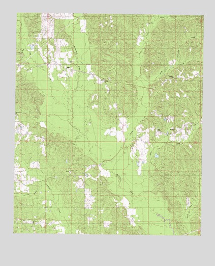
Sykes, MS USGS Topographic Map
Click on map above to begin viewing in our Map Viewer.

This topographic map contains these locations and features:
Feature Name Type Latitude Longitude GNIS ID View Map
Davis BridgeBridgeN32.0921°W88.5825°687502View Map
Dunnam School (historical)SchoolN32.1201°W88.5056°687505View Map
Elim CemeteryCemeteryN32.0351°W88.5875°709425View Map
Elim ChurchChurchN32.0354°W88.5881°690791View Map
Elim School (historical)SchoolN32.0351°W88.5881°709426View Map
Grace Bible ChurchChurchN32.1201°W88.5373°690794View Map
Graham Store (historical)LocaleN32.0607°W88.5528°687516View Map
Greasy CreekStreamN32.0832°W88.5400°670641View Map
Hopewell ChurchChurchN32.0874°W88.5656°690795View Map
Hopewell SchoolSchoolN32.0851°W88.5589°671448View Map
Hopewell Volunteer Fire Department QuitmanBuildingN32.0851°W88.5582°2667910View Map
Indian CreekStreamN32.1215°W88.5320°690796View Map
Ivy Mill CreekStreamN32.0985°W88.6164°671753View Map
James ChapelChurchN32.0596°W88.5298°671802View Map
Johnson Bridge (historical)BridgeN32.0488°W88.5748°687525View Map
LintonPopulated PlaceN32.0343°W88.5875°692006View Map
Long BranchStreamN32.0251°W88.6000°672808View Map
Long CreekStreamN32.0635°W88.5875°672819View Map
Motts CreekStreamN32.0204°W88.5361°673894View Map
Mount Gillard ChurchChurchN32.0593°W88.5189°674008View Map
New Home ChurchChurchN32.0896°W88.5175°674648View Map
New Home School (historical)SchoolN32.0890°W88.5184°687543View Map
Pine Grove CemeteryCemeteryN32.0065°W88.6125°709464View Map
Pine Grove ChurchChurchN32.0065°W88.6120°675834View Map
Pine Grove School (historical)SchoolN32.0054°W88.6006°687548View Map
Rattlesnake CreekStreamN32.0974°W88.5167°690806View Map
Rocky CreekStreamN32.0357°W88.5592°676788View Map
Slay BridgeBridgeN32.0396°W88.5673°687554View Map
SykesPopulated PlaceN32.0940°W88.5923°692253View Map
Theads Store (historical)LocaleN32.0046°W88.5445°687559View Map

Note: Coordinates in the location and feature list above are referenced to NAD83 datum.


Copyright (C) 2008-2025 Ryan Niemi / Sunset Dynamics ... All Rights Reserved