TopoQuest Logo
Do you find TopoQuest useful?
Help keep TopoQuest running and adding new maps/features by donating!
Bitcoin:  19c7KJd3qBynnjoSw5npx9KScwjBe4ifkT
Litecoin:  LXs6TkuXGGXo1vDsWCkWVdjQX94eUKd6ui
Home View Maps Find Maps Find Places Resources & Links


Wolf Mountain, Oregon Topographic Map

USGS Map Title: Wolf Mountain, OR
USGS Map MRC: 44119C6
DRG (GeoTIFF) Download: o44119c6.tif


Neighboring USGS Topographic Map Quads:


  Antone, OR  
44119D7
 

  Day Basin, OR  
44119D6
 

  Dayville, OR  
44119D5
 

  Six Corners, OR  
44119C7
 

  Wolf Mountain, OR  
44119C6
 

  Aldrich Gulch, OR  
44119C5
 

  Mud Spring, OR  
44119B7
 

  Powell Mountain, OR  
44119B6
 

  Suplee Butte, OR  
44119B5


Map MRC Location:

N45°
W120°
N45°
W119°
H8 H7 H6 H5 H4 H3 H2 H1
G8 G7 G6 G5 G4 G3 G2 G1
F8 F7 F6 F5 F4 F3 F2 F1
E8 E7 E6 E5 E4 E3 E2 E1
D8 D7 D6 D5 D4 D3 D2 D1
C8 C7 C6 C5 C4 C3 C2 C1
B8 B7 B6 B5 B4 B3 B2 B1
A8 A7 A6 A5 A4 A3 A2 A1
N44°
W120°
N44°
W119°

Wolf Mountain, OR USGS 1:24K Topographic Map Preview:
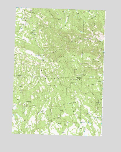
Wolf Mountain, OR USGS Topographic Map
Click on map above to begin viewing in our Map Viewer.

This topographic map contains these locations and features:
Feature Name Type Latitude Longitude GNIS ID View Map
A and M SpringSpringN44.3741°W119.6500°1136989View Map
Aspen ReservoirReservoirN44.2533°W119.6806°1137330View Map
Battle RidgeRidgeN44.3093°W119.7089°1137600View Map
Battle Ridge ReservoirReservoirN44.2978°W119.7010°1137601View Map
Bay Steer CreekStreamN44.3440°W119.6275°1137607View Map
Bear SkullSummitN44.3656°W119.7125°1137742View Map
Beaverdam ReservoirReservoirN44.2826°W119.6667°1137859View Map
Bellwether SpringSpringN44.3643°W119.6908°1137904View Map
Black Canyon TrailTrailN44.3401°W119.7194°1138193View Map
Black Canyon WildernessReserveN44.3386°W119.6542°1638092View Map
Blue Jay ReservoirReservoirN44.2747°W119.6839°1117845View Map
Box SpringSpringN44.2791°W119.7293°1138539View Map
Buck ReservoirReservoirN44.2635°W119.6961°1138818View Map
Coffeepot TrailTrailN44.3560°W119.6844°1139898View Map
Congleton Creek ReservoirReservoirN44.3041°W119.6272°1150266View Map
Crow ReservoirReservoirN44.2601°W119.6780°1140487View Map
Crowbar SpringSpringN44.3243°W119.6354°1140489View Map
Dead End ReservoirReservoirN44.2808°W119.6730°1140685View Map
Doby SpringSpringN44.2557°W119.7141°1141096View Map
Dry Gulch ReservoirReservoirN44.3007°W119.6371°1141338View Map
Dusty Camp SpringsSpringN44.3246°W119.7085°1141423View Map
Dutch ReservoirReservoirN44.2671°W119.6861°1141434View Map
Eagle ReservoirReservoirN44.2611°W119.6863°1141487View Map
East Wolf LookoutLocaleN44.3268°W119.7066°1167632View Map
Hat SpringSpringN44.3164°W119.6805°1143359View Map
Honeymoon BasinBasinN44.3349°W119.6891°1143696View Map
Honeymoon CreekStreamN44.3451°W119.6805°1143698View Map
Humphreys CampLocaleN44.3704°W119.7250°1143913View Map
Humphreys PastureFlatN44.3276°W119.7303°1130976View Map
Kelsey ReservoirReservoirN44.3674°W119.6414°1144547View Map
Kelsey SpringSpringN44.3677°W119.6410°1144548View Map
Lloyd SpringSpringN44.3551°W119.7429°1145306View Map
Mud ReservoirReservoirN44.3000°W119.6631°1146583View Map
Mud SpringSpringN44.3021°W119.6645°1146595View Map
Mud Springs Recreation SiteLocaleN44.3021°W119.6469°1156304View Map
Owl CreekStreamN44.3551°W119.7016°1147310View Map
Owl Creek MeadowSwampN44.3508°W119.6968°1147312View Map
Owl Creek TrailTrailN44.3443°W119.7283°1147313View Map
Princess RidgeRidgeN44.3538°W119.6594°1148001View Map
Robin ReservoirReservoirN44.2636°W119.7314°1148544View Map
Saddle Camp SpringSpringN44.3460°W119.6697°1148902View Map
South Prong ReservoirReservoirN44.3148°W119.6672°1150071View Map
South Prong TrailTrailN44.3235°W119.6316°1150072View Map
South Prong TroughsSpringN44.3106°W119.6543°1150073View Map
South Wind Creek ReservoirReservoirN44.2686°W119.6335°1150094View Map
Tamarack ButteSummitN44.2996°W119.7164°1150853View Map
Tamarack Butte ReservoirReservoirN44.2813°W119.7247°1150854View Map
Tamarack SpringSpringN44.2964°W119.7396°1150878View Map
Three ForksPopulated PlaceN44.2832°W119.6289°1151165View Map
Twin SpringsSpringN44.3738°W119.7469°1151592View Map
West Wolf LookoutLocaleN44.3285°W119.7158°1167633View Map
Wolf MountainSummitN44.3282°W119.7155°1152594View Map

Note: Coordinates in the location and feature list above are referenced to NAD83 datum.


Copyright (C) 2008-2025 Ryan Niemi / Sunset Dynamics ... All Rights Reserved