TopoQuest Logo
Do you find TopoQuest useful?
Help keep TopoQuest running and adding new maps/features by donating!
Bitcoin:  19c7KJd3qBynnjoSw5npx9KScwjBe4ifkT
Litecoin:  LXs6TkuXGGXo1vDsWCkWVdjQX94eUKd6ui
Home View Maps Find Maps Find Places Resources & Links


Hillsboro, Wisconsin Topographic Map

USGS Map Title: Hillsboro, WI
USGS Map MRC: 43090F3
DRG (GeoTIFF) Download: o43090f3.tif


Neighboring USGS Topographic Map Quads:


  Kendall West, WI  
43090G4
 

  Kendall East, WI  
43090G3
 

  New Lisbon South, WI  
43090G2
 

  Trippville, WI  
43090F4
 

  Hillsboro, WI  
43090F3
 

  Wonewoc, WI  
43090F2
 

  Yuba, WI  
43090E4
 

  Valton, WI  
43090E3
 

  La Valle, WI  
43090E2


Map MRC Location:

N44°
W91°
N44°
W90°
H8 H7 H6 H5 H4 H3 H2 H1
G8 G7 G6 G5 G4 G3 G2 G1
F8 F7 F6 F5 F4 F3 F2 F1
E8 E7 E6 E5 E4 E3 E2 E1
D8 D7 D6 D5 D4 D3 D2 D1
C8 C7 C6 C5 C4 C3 C2 C1
B8 B7 B6 B5 B4 B3 B2 B1
A8 A7 A6 A5 A4 A3 A2 A1
N43°
W91°
N43°
W90°

Hillsboro, WI USGS 1:24K Topographic Map Preview:
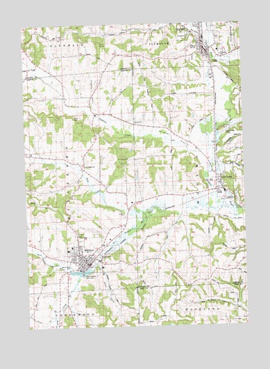
Hillsboro, WI USGS Topographic Map
Click on map above to begin viewing in our Map Viewer.

This topographic map contains these locations and features:
Feature Name Type Latitude Longitude GNIS ID View Map
Beaver CreekStreamN43.6297°W90.3624°1561444View Map
City of ElroyCivilN43.7421°W90.2706°1583161View Map
City of HillsboroCivilN43.6560°W90.3365°1583393View Map
Deadman HollowValleyN43.7131°W90.3332°1563781View Map
Dutch ValleyValleyN43.6506°W90.3351°1564215View Map
ElroyPopulated PlaceN43.7408°W90.2724°1564593View Map
Elroy Area Fire Department and AmbulanceBuildingN43.7393°W90.2699°2697694View Map
Elroy City CemeteryCemeteryN43.7355°W90.2776°1834296View Map
Elroy Municipal AirportAirportN43.7064°W90.2576°1581969View Map
Elroy Police DepartmentBuildingN43.7387°W90.2706°2759946View Map
Elroy Wastewater Treatment FacilityLocaleN43.7347°W90.2646°2729074View Map
Field Veterans Memorial LakeReservoirN43.6477°W90.3440°1834453View Map
First Congregational ChurchChurchN43.6503°W90.3432°1834454View Map
Grace Lutheran ChurchChurchN43.7483°W90.2762°1834302View Map
Gross ValleyValleyN43.6264°W90.3677°1565917View Map
Hills CreekStreamN43.6716°W90.3096°1566444View Map
Hills Prairie CemeteryCemeteryN43.6919°W90.3451°1566448View Map
HillsboroPopulated PlaceN43.6522°W90.3440°1566449View Map
Hillsboro 2WP1317 DamDamN43.6483°W90.3385°1792268View Map
Hillsboro Area Ambulance ServiceBuildingN43.6492°W90.3458°2698391View Map
Hillsboro Elementary SchoolSchoolN43.6580°W90.3497°1834462View Map
Hillsboro High SchoolSchoolN43.6567°W90.3516°1834463View Map
Hillsboro Police DepartmentBuildingN43.6517°W90.3400°2759490View Map
Hillsboro Pond 76ReservoirN43.6477°W90.3440°1792269View Map
Hillsboro Post OfficePost OfficeN43.6514°W90.3393°1834750View Map
Hillsboro Public LibraryBuildingN43.6525°W90.3414°2709496View Map
Hillsboro Volunteer Fire DepartmentBuildingN43.6569°W90.3331°2698147View Map
Hillsboro Wastewater Treatment FacilityLocaleN43.6542°W90.3336°2709495View Map
Hillsboro Wesleyan ChurchChurchN43.6539°W90.3387°1834464View Map
Immanuel Missionary Church (historical)ChurchN43.6539°W90.3387°1834751View Map
Joshua Sanford FieldAirportN43.6552°W90.3309°1582012View Map
Kimballs BluffCliffN43.7086°W90.2576°1567485View Map
Millards PrairieFlatN43.7036°W90.2929°1569502View Map
Millards Prairie ChurchChurchN43.7086°W90.3140°1569503View Map
Mount Vernon CemeteryCemeteryN43.6497°W90.3515°1569856View Map
Pikes PeakSummitN43.7119°W90.3446°1571395View Map
Pine KnobSummitN43.7416°W90.3346°1571481View Map
Saint Aloysius ChurchChurchN43.6497°W90.3432°1834489View Map
Saint Joseph Hospital (historical)HospitalN43.6486°W90.3451°1834752View Map
Saint Josephs Community Health ServicesHospitalN43.6487°W90.3453°2698467View Map
Saint Josephs Memorial Hospital HeliportAirportN43.6486°W90.3457°1582013View Map
Saint Josephs Nursing HomeHospitalN43.6483°W90.3451°1834490View Map
Saint Lukes ChurchChurchN43.7447°W90.3579°1573228View Map
Saint Patricks Catholic ChurchChurchN43.7366°W90.2699°1834340View Map
Saint Patricks CemeteryCemeteryN43.7369°W90.2618°1834341View Map
Saint Paul Lutheran ChurchChurchN43.6503°W90.3443°1834492View Map
Seymour CreekStreamN43.6969°W90.2699°1573936View Map
South Branch CreekStreamN43.6464°W90.3449°1574397View Map
The PinnacleSummitN43.6936°W90.3215°1575341View Map
Tiedtke ValleyValleyN43.7028°W90.2657°1575440View Map
Tinkers BluffCliffN43.6625°W90.3474°1575467View Map
Town of HillsboroCivilN43.6855°W90.3736°1583394View Map
Town of WonewocCivilN43.6876°W90.2528°1584471View Map
Union CenterPopulated PlaceN43.6853°W90.2668°1575898View Map
Union Center Police DepartmentBuildingN43.6845°W90.2638°2759947View Map
Union Center Volunteer Fire DepartmentBuildingN43.6845°W90.2638°2697586View Map
Village of Union CenterCivilN43.6826°W90.2633°1584316View Map
West Branch Baraboo RiverStreamN43.6755°W90.2643°1576457View Map

Note: Coordinates in the location and feature list above are referenced to NAD83 datum.


Copyright (C) 2008-2025 Ryan Niemi / Sunset Dynamics ... All Rights Reserved