TopoQuest Logo
Do you find TopoQuest useful?
Help keep TopoQuest running and adding new maps/features by donating!
Bitcoin:  19c7KJd3qBynnjoSw5npx9KScwjBe4ifkT
Litecoin:  LXs6TkuXGGXo1vDsWCkWVdjQX94eUKd6ui
Home View Maps Find Maps Find Places Resources & Links


Sherburne, New York Topographic Map

USGS Map Title: Sherburne, NY
USGS Map MRC: 42075F4
DRG (GeoTIFF) Download: o42075f4.tif


Neighboring USGS Topographic Map Quads:


  Hamilton, NY  
42075G5
 

  Hubbardsville, NY  
42075G4
 

  Brookfield, NY  
42075G3
 

  Earlville, NY  
42075F5
 

  Sherburne, NY  
42075F4
 

  New Berlin North, NY  
42075F3
 

  Norwich, NY  
42075E5
 

  Holmesville, NY  
42075E4
 

  New Berlin South, NY  
42075E3


Map MRC Location:

N43°
W76°
N43°
W75°
H8 H7 H6 H5 H4 H3 H2 H1
G8 G7 G6 G5 G4 G3 G2 G1
F8 F7 F6 F5 F4 F3 F2 F1
E8 E7 E6 E5 E4 E3 E2 E1
D8 D7 D6 D5 D4 D3 D2 D1
C8 C7 C6 C5 C4 C3 C2 C1
B8 B7 B6 B5 B4 B3 B2 B1
A8 A7 A6 A5 A4 A3 A2 A1
N42°
W76°
N42°
W75°

Sherburne, NY USGS 1:24K Topographic Map Preview:
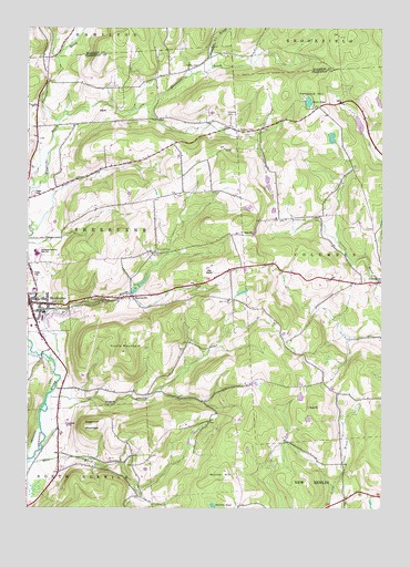
Sherburne, NY USGS Topographic Map
Click on map above to begin viewing in our Map Viewer.

This topographic map contains these locations and features:
Feature Name Type Latitude Longitude GNIS ID View Map
Campbell CemeteryCemeteryN42.7006°W75.4019°945698View Map
Christ Episcopal ChurchChurchN42.6795°W75.4963°2426564View Map
Christian Baptist ChurchChurchN42.7396°W75.4935°2615730View Map
Columbus HillSummitN42.7348°W75.4007°947203View Map
East Hill CemeteryCemeteryN42.6917°W75.4539°949120View Map
First Congregational ChurchChurchN42.6777°W75.4982°2426566View Map
HarrisvillePopulated PlaceN42.6801°W75.4630°952290View Map
Harrisville CemeteryCemeteryN42.6802°W75.4648°2776883View Map
Harrisville CemeteryCemeteryN42.6800°W75.4647°2559149View Map
Howard CemeteryCemeteryN42.7273°W75.4291°953303View Map
Hunts MountainSummitN42.6656°W75.4660°953510View Map
Jackson PondLakeN42.6255°W75.4343°953892View Map
Mad BrookStreamN42.6631°W75.4905°956243View Map
Mountain Top Golf CourseLocaleN42.6863°W75.4358°2615444View Map
Negro HollowValleyN42.6531°W75.4827°958343View Map
Negro Hollow ChurchChurchN42.6545°W75.4474°958345View Map
Number Six BrookStreamN42.7401°W75.4352°970415View Map
Palmer CemeteryCemeteryN42.7403°W75.4397°959784View Map
Pleasant BrookStreamN42.7253°W75.4891°960704View Map
Pratt - Newton Memorial HomeBuildingN42.6766°W75.4987°2614756View Map
Rexford FallsFallsN42.6790°W75.4713°970520View Map
Saint Malachy CemeteryCemeteryN42.6883°W75.4930°2123384View Map
Saint Malachy's Roman Catholic ChurchChurchN42.6785°W75.4964°2426565View Map
School Number 1 (historical)SchoolN42.6453°W75.4891°974890View Map
School Number 1 (historical)SchoolN42.7284°W75.4971°974901View Map
School Number 11 (historical)SchoolN42.7076°W75.4449°974982View Map
School Number 12 (historical)SchoolN42.7262°W75.4349°975030View Map
School Number 13 (historical)SchoolN42.7378°W75.4532°975057View Map
School Number 15 (historical)SchoolN42.6795°W75.4257°975106View Map
School Number 5 (historical)SchoolN42.7012°W75.4016°975412View Map
School Number 6 (historical)SchoolN42.7290°W75.3991°975485View Map
Sears PondLakeN42.7308°W75.4010°964748View Map
SherburnePopulated PlaceN42.6781°W75.4985°965062View Map
Sherburne - Earlville Elementary SchoolSchoolN42.6899°W75.4942°2668905View Map
Sherburne - Earlville Middle SchoolSchoolN42.6917°W75.4973°2669185View Map
Sherburne Baptist ChurchChurchN42.6798°W75.4973°2426562View Map
Sherburne Central SchoolSchoolN42.6759°W75.4939°2426568View Map
Sherburne GrangeLocaleN42.6802°W75.4994°2426563View Map
Sherburne Post OfficePost OfficeN42.6777°W75.4996°2618118View Map
Sherburne Public LibraryBuildingN42.6778°W75.4979°2426567View Map
Sherburne Senior Housing CenterBuildingN42.6759°W75.4940°2614787View Map
Sherburne United Methodist ChurchChurchN42.6763°W75.4963°2426569View Map
Sherburne-Earlville High SchoolSchoolN42.6912°W75.4967°2426561View Map
Skinner HillSummitN42.6345°W75.4299°965358View Map
Sugarloaf MountainSummitN42.6465°W75.4771°966730View Map
Tillotson CemeteryCemeteryN42.7235°W75.4257°967524View Map
Town of SherburneCivilN42.6924°W75.4833°979490View Map
Village of SherburneCivilN42.6806°W75.4965°2391129View Map
West BrookStreamN42.6367°W75.4999°969150View Map

Note: Coordinates in the location and feature list above are referenced to NAD83 datum.


Copyright (C) 2008-2025 Ryan Niemi / Sunset Dynamics ... All Rights Reserved