TopoQuest Logo
Do you find TopoQuest useful?
Help keep TopoQuest running and adding new maps/features by donating!
Bitcoin:  19c7KJd3qBynnjoSw5npx9KScwjBe4ifkT
Litecoin:  LXs6TkuXGGXo1vDsWCkWVdjQX94eUKd6ui
Home View Maps Find Maps Find Places Resources & Links


Wyalusing, Pennsylvania Topographic Map

USGS Map Title: Wyalusing, PA
USGS Map MRC: 41076F3
DRG (GeoTIFF) Download: o41076f3.tif


Neighboring USGS Topographic Map Quads:


  Towanda, PA  
41076G4
 

  Rome, PA  
41076G3
 

  Le Raysville, PA  
41076G2
 

  Monroeton, PA  
41076F4
 

  Wyalusing, PA  
41076F3
 

  Laceyville, PA  
41076F2
 

  Dushore, PA  
41076E4
 

  Colley, PA  
41076E3
 

  Jenningsville, PA  
41076E2


Map MRC Location:

N42°
W77°
N42°
W76°
H8 H7 H6 H5 H4 H3 H2 H1
G8 G7 G6 G5 G4 G3 G2 G1
F8 F7 F6 F5 F4 F3 F2 F1
E8 E7 E6 E5 E4 E3 E2 E1
D8 D7 D6 D5 D4 D3 D2 D1
C8 C7 C6 C5 C4 C3 C2 C1
B8 B7 B6 B5 B4 B3 B2 B1
A8 A7 A6 A5 A4 A3 A2 A1
N41°
W77°
N41°
W76°

Wyalusing, PA USGS 1:24K Topographic Map Preview:
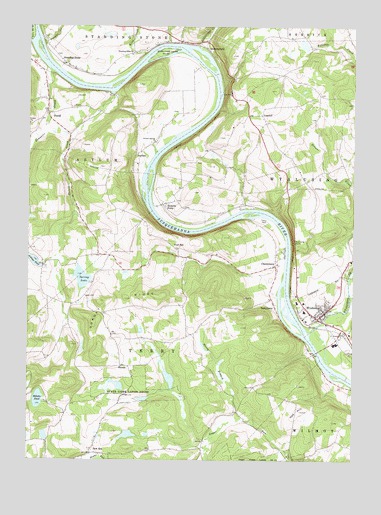
Wyalusing, PA USGS Topographic Map
Click on map above to begin viewing in our Map Viewer.

This topographic map contains these locations and features:
Feature Name Type Latitude Longitude GNIS ID View Map
Ackleys PondReservoirN41.6824°W76.3727°1168049View Map
AsylumPopulated PlaceN41.7131°W76.3335°1202995View Map
Bennetts CreekStreamN41.7370°W76.3666°1198413View Map
Biles CemeteryCemeteryN41.7110°W76.3105°2776407View Map
Billetts PondLakeN41.6424°W76.3706°1169621View Map
Borough of WyalusingCivilN41.6703°W76.2623°1214961View Map
Brewer CreekStreamN41.6773°W76.2516°1198472View Map
CherrytownPopulated PlaceN41.6812°W76.2791°1203261View Map
Decker CemeteryCemeteryN41.7248°W76.3666°2776417View Map
DurellPopulated PlaceN41.7254°W76.3677°1173635View Map
Durell CemeteryCemeteryN41.7203°W76.3712°2776419View Map
Durell CreekStreamN41.7309°W76.3433°1173636View Map
Ellis CreekStreamN41.7184°W76.3710°1174157View Map
French Asylum ChurchChurchN41.7167°W76.3260°1175219View Map
French AzilumLocaleN41.7384°W76.3097°1206829View Map
French Azilum OverlookLocaleN41.7306°W76.2974°1205138View Map
Frenchtown CemeteryCemeteryN41.7168°W76.3261°2776432View Map
Frenchtown Old CemeteryCemeteryN41.7252°W76.3180°2776433View Map
Gordon CemeteryCemeteryN41.7466°W76.3689°2776435View Map
Homet CemeteryCemeteryN41.6980°W76.3150°2776444View Map
Homets FerryPopulated PlaceN41.6990°W76.3227°1200089View Map
King CreekStreamN41.7420°W76.3302°1178474View Map
Laporte Family CemeteryCemeteryN41.7364°W76.3136°2776451View Map
Lime Hill CemeteryCemeteryN41.7247°W76.2866°2776456View Map
LimehillPopulated PlaceN41.7248°W76.2852°1204027View Map
New EraPopulated PlaceN41.6270°W76.3499°1204275View Map
New Era CemeteryCemeteryN41.6309°W76.3484°2776470View Map
North Branch Sugar RunStreamN41.6373°W76.2949°1182554View Map
Norway RidgeRidgeN41.6709°W76.3394°1182689View Map
Norway Ridge School (historical)SchoolN41.6626°W76.3138°1197356View Map
Oak HillSummitN41.6392°W76.2694°1182765View Map
Oak Hill SchoolSchoolN41.6256°W76.2719°1197355View Map
Pa-798 ReservoirReservoirN41.6451°W76.3280°1195718View Map
Pa-799 ReservoirReservoirN41.6466°W76.3401°1195720View Map
RienzePopulated PlaceN41.6520°W76.3360°1204507View Map
RummerfieldPopulated PlaceN41.7440°W76.3066°1185616View Map
Rummerfield CreekStreamN41.7440°W76.3088°1185617View Map
Scriven Dam Number OneDamN41.6451°W76.3280°1195717View Map
Spring LakeLakeN41.6775°W76.3539°1188239View Map
Spring Lake SchoolSchoolN41.6698°W76.3558°1197353View Map
Standing StonePopulated PlaceN41.7395°W76.3613°1188392View Map
Standing Stone CemeteryCemeteryN41.7414°W76.3349°2776501View Map
Standing Stone ChurchChurchN41.7420°W76.3352°1188393View Map
State Game Lands Number 237ParkN41.7420°W76.3247°1188500View Map
State Game Lands Number 250ParkN41.6462°W76.3347°1188505View Map
Sugar Run Dam Number 103DamN41.6451°W76.3413°1195719View Map
TerrytownPopulated PlaceN41.6695°W76.2799°1204805View Map
Terrytown CemeteryCemeteryN41.6815°W76.2785°2776506View Map
Towanda Gun ClubLocaleN41.6970°W76.3383°1197352View Map
Township of AsylumCivilN41.7133°W76.3737°1215973View Map
Township of TerryCivilN41.6429°W76.3323°1215997View Map
Township of WyalusingCivilN41.7049°W76.2541°1216007View Map
Viall HillPopulated PlaceN41.6859°W76.3166°1204874View Map
Vought CreekStreamN41.7454°W76.3697°1190456View Map
Wellstown SchoolSchoolN41.6495°W76.3341°1197354View Map
WyalusingPopulated PlaceN41.6681°W76.2619°1191818View Map
Wyalusing CemeteryCemeteryN41.6592°W76.2546°2776527View Map
Wyalusing CreekStreamN41.6617°W76.2663°1191819View Map
Wyalusing Post OfficePost OfficeN41.6663°W76.2623°2773289View Map
Wyalusing RocksCliffN41.6884°W76.2727°1191820View Map
Wyalusing StationLocaleN41.6609°W76.2522°1212954View Map
Wyalusing Valley Volunteer Fire DepartmentBuildingN41.6664°W76.2655°2653401View Map

Note: Coordinates in the location and feature list above are referenced to NAD83 datum.


Copyright (C) 2008-2025 Ryan Niemi / Sunset Dynamics ... All Rights Reserved