TopoQuest Logo
Do you find TopoQuest useful?
Help keep TopoQuest running and adding new maps/features by donating!
Bitcoin:  19c7KJd3qBynnjoSw5npx9KScwjBe4ifkT
Litecoin:  LXs6TkuXGGXo1vDsWCkWVdjQX94eUKd6ui
Home View Maps Find Maps Find Places Resources & Links


Falls Creek, Pennsylvania Topographic Map

USGS Map Title: Falls Creek, PA
USGS Map MRC: 41078B7
DRG (GeoTIFF) Download: o41078b7.tif


Neighboring USGS Topographic Map Quads:


  Munderf, PA  
41078C8
 

  Carman, PA  
41078C7
 

  Brandy Camp, PA  
41078C6
 

  Hazen, PA  
41078B8
 

  Falls Creek, PA  
41078B7
 

  Sabula, PA  
41078B6
 

  Reynoldsville, PA  
41078A8
 

  Du Bois, PA  
41078A7
 

  Luthersburg, PA  
41078A6


Map MRC Location:

N42°
W79°
N42°
W78°
H8 H7 H6 H5 H4 H3 H2 H1
G8 G7 G6 G5 G4 G3 G2 G1
F8 F7 F6 F5 F4 F3 F2 F1
E8 E7 E6 E5 E4 E3 E2 E1
D8 D7 D6 D5 D4 D3 D2 D1
C8 C7 C6 C5 C4 C3 C2 C1
B8 B7 B6 B5 B4 B3 B2 B1
A8 A7 A6 A5 A4 A3 A2 A1
N41°
W79°
N41°
W78°

Falls Creek, PA USGS 1:24K Topographic Map Preview:
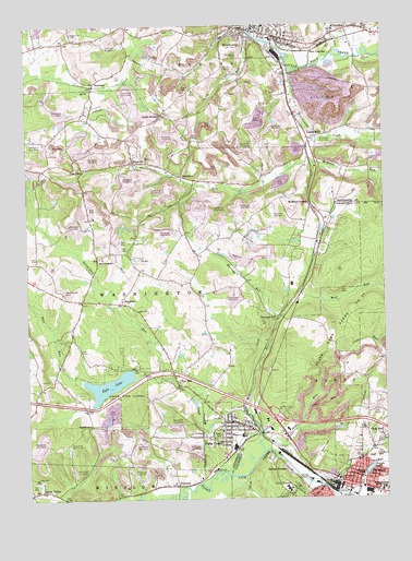
Falls Creek, PA USGS Topographic Map
Click on map above to begin viewing in our Map Viewer.

This topographic map contains these locations and features:
Feature Name Type Latitude Longitude GNIS ID View Map
Adrian FurnacePopulated PlaceN41.1320°W78.7836°1168084View Map
Adrian Sandy Fire Company Station 38BuildingN41.1278°W78.7782°2645707View Map
Beaver RunStreamN41.1251°W78.7625°1169040View Map
Beaverdam RunStreamN41.1576°W78.8281°1169064View Map
BeechtonPopulated PlaceN41.2348°W78.8506°1203051View Map
BeechtreePopulated PlaceN41.2101°W78.8206°1203052View Map
BeechwoodsPopulated PlaceN41.1887°W78.8500°1205024View Map
Beechwoods CemeteryCemeteryN41.1798°W78.8621°1169120View Map
Beechwoods SchoolsSchoolN41.1890°W78.8486°1206436View Map
Borough of BrockwayCivilN41.2469°W78.7929°1215298View Map
Borough of Falls CreekCivilN41.1421°W78.8067°1217324View Map
BrockwayPopulated PlaceN41.2492°W78.7995°1209445View Map
Brockway Area Ambulance Service Station 10BuildingN41.2438°W78.7871°2719488View Map
Brockway Police DepartmentBuildingN41.2492°W78.7980°2777121View Map
Brockway Post OfficePost OfficeN41.2491°W78.8006°2779642View Map
Brockway Volunteer Hose Company - Station 1BuildingN41.2475°W78.7945°2645238View Map
Bywatler Landing Strip (historical)AirportN41.1648°W78.8036°1206681View Map
Clear RunPopulated PlaceN41.1376°W78.7548°1171965View Map
Clear RunStreamN41.1278°W78.7703°1171969View Map
Clear Run School (historical)SchoolN41.1409°W78.7514°1206441View Map
Coal GlenPopulated PlaceN41.2117°W78.8548°1192279View Map
Cravens (historical)LocaleN41.2120°W78.8531°1201686View Map
Crawford School (historical)SchoolN41.1578°W78.8720°1206439View Map
CrenshawPopulated PlaceN41.2487°W78.7620°1209536View Map
Crenshaw Census Designated PlaceCensusN41.2487°W78.7543°2630002View Map
Curry RunStreamN41.2473°W78.7959°1172846View Map
Curry Run CampLocaleN41.2381°W78.8036°1172849View Map
DetwoodPopulated PlaceN41.2323°W78.7828°1201687View Map
Erie JunctionPopulated PlaceN41.2431°W78.7736°1203527View Map
Falls CreekStreamN41.1495°W78.7998°1174601View Map
Falls CreekPopulated PlaceN41.1451°W78.8045°1192448View Map
Falls Creek Post OfficePost OfficeN41.1446°W78.7993°2772699View Map
Falls Creek Volunteer Fire Department Station 4BuildingN41.1461°W78.7986°2644774View Map
Frost School (historical)SchoolN41.2353°W78.8125°1206445View Map
Groves School (historical)SchoolN41.1920°W78.7914°1206435View Map
Harveys RunStreamN41.1723°W78.7867°1176630View Map
Harveys RunPopulated PlaceN41.1726°W78.7875°1203756View Map
Interchange 16CrossingN41.1303°W78.7895°1209128View Map
Iselin HeightsPopulated PlaceN41.1273°W78.7850°1177877View Map
Juniata Elementary SchoolSchoolN41.1315°W78.7586°1210636View Map
Juniata LakeLakeN41.1324°W78.7561°1178197View Map
Kyle LakeReservoirN41.1551°W78.8466°1178717View Map
Kyle RunStreamN41.1562°W78.8559°1178718View Map
Lanes MillsPopulated PlaceN41.2201°W78.7759°1178860View Map
McEwen RunStreamN41.2173°W78.7759°1180708View Map
McMinns SummitPopulated PlaceN41.2028°W78.7753°1204138View Map
Miller SchoolSchoolN41.2492°W78.8256°1206444View Map
PancoastPopulated PlaceN41.1287°W78.8228°1204353View Map
Pennsylvania State Police Troop C DuBois StationBuildingN41.1482°W78.8124°2777330View Map
Pennsylvania State University Du Bois CampusSchoolN41.1270°W78.7520°1210754View Map
Rattlesnake CreekStreamN41.2373°W78.7814°1184669View Map
Rattlesnake RunStreamN41.2195°W78.7739°1184680View Map
Red MillPopulated PlaceN41.1551°W78.8220°1184768View Map
RockdalePopulated PlaceN41.1767°W78.8417°1185302View Map
Rockdale School (historical)SchoolN41.1845°W78.8328°1206437View Map
Sandy PlazaLocaleN41.1434°W78.7848°1206674View Map
Serect School (historical)SchoolN41.2209°W78.8448°1206442View Map
Sherwood Station (historical)LocaleN41.1262°W78.8739°1206446View Map
Slab RunStreamN41.1373°W78.7895°1187774View Map
Smith SummitPopulated PlaceN41.2267°W78.8270°1204670View Map
SmithtownPopulated PlaceN41.1445°W78.8528°1204673View Map
Smithtown SchoolSchoolN41.1415°W78.8284°1206440View Map
State Fish LandsParkN41.1667°W78.8331°1209199View Map
Sugar Hill CemeteryCemeteryN41.2482°W78.8583°1188943View Map
Sugar Hill SchoolSchoolN41.2456°W78.8609°1206443View Map
Third Ward Hose Company - John Edwards Dubois Hose Company Station 73BuildingN41.1303°W78.7580°2644833View Map
Township of WashingtonCivilN41.1807°W78.8570°1216575View Map
Waite School (historical)SchoolN41.1776°W78.8542°1206438View Map
Walburn RunStreamN41.2423°W78.7667°1210226View Map
WCED-AM (Du Bois)TowerN41.1420°W78.8017°1200482View Map
WestvillePopulated PlaceN41.2140°W78.8367°1191184View Map
Wildwood CemeteryCemeteryN41.2421°W78.7986°1191428View Map
Wolf RunStreamN41.1373°W78.7931°1191684View Map
Wolf RunStreamN41.1784°W78.7775°1213078View Map

Note: Coordinates in the location and feature list above are referenced to NAD83 datum.


Copyright (C) 2008-2025 Ryan Niemi / Sunset Dynamics ... All Rights Reserved