TopoQuest Logo
Do you find TopoQuest useful?
Help keep TopoQuest running and adding new maps/features by donating!
Bitcoin:  19c7KJd3qBynnjoSw5npx9KScwjBe4ifkT
Litecoin:  LXs6TkuXGGXo1vDsWCkWVdjQX94eUKd6ui
Home View Maps Find Maps Find Places Resources & Links


Hadley, Pennsylvania Topographic Map

USGS Map Title: Hadley, PA
USGS Map MRC: 41080D2
DRG (GeoTIFF) Download: o41080d2.tif


Neighboring USGS Topographic Map Quads:


  Conneaut Lake, PA  
41080E3
 

  Geneva, PA  
41080E2
 

  Cochranton, PA  
41080E1
 

  Greenville East, PA  
41080D3
 

  Hadley, PA  
41080D2
 

  New Lebanon, PA  
41080D1
 

  Fredonia, PA  
41080C3
 

  Jackson Center, PA  
41080C2
 

  Sandy Lake, PA  
41080C1


Map MRC Location:

N42°
W81°
N42°
W80°
H8 H7 H6 H5 H4 H3 H2 H1
G8 G7 G6 G5 G4 G3 G2 G1
F8 F7 F6 F5 F4 F3 F2 F1
E8 E7 E6 E5 E4 E3 E2 E1
D8 D7 D6 D5 D4 D3 D2 D1
C8 C7 C6 C5 C4 C3 C2 C1
B8 B7 B6 B5 B4 B3 B2 B1
A8 A7 A6 A5 A4 A3 A2 A1
N41°
W81°
N41°
W80°

Hadley, PA USGS 1:24K Topographic Map Preview:
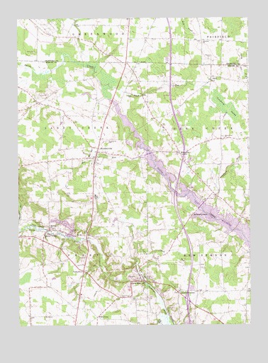
Hadley, PA USGS Topographic Map
Click on map above to begin viewing in our Map Viewer.

This topographic map contains these locations and features:
Feature Name Type Latitude Longitude GNIS ID View Map
Bell School (historical)SchoolN41.4345°W80.1817°1205359View Map
Black RunStreamN41.4712°W80.2042°1199837View Map
Borland SchoolSchoolN41.4034°W80.1359°1206660View Map
Borough of SheakleyvilleCivilN41.4438°W80.2067°1215449View Map
Caldwell CemeteryCemeteryN41.4689°W80.1878°1199842View Map
Calvin Clark RunStreamN41.4081°W80.1862°1199844View Map
Camp PerryLocaleN41.3970°W80.2148°1199845View Map
Camp WilhelmLocaleN41.4234°W80.1648°1208083View Map
Carpenter CornersLocaleN41.3884°W80.1640°1199847View Map
Clark Mills Post OfficePost OfficeN41.3944°W80.1848°2772636View Map
Clarks MillsPopulated PlaceN41.3931°W80.1837°1199848View Map
Cranberry SwampSwampN41.4642°W80.1379°1199853View Map
Deer Creek School (historical)SchoolN41.4576°W80.2309°1205358View Map
Five PointsPopulated PlaceN41.3781°W80.2078°1205044View Map
Fletcher AirportAirportN41.4422°W80.1548°1194233View Map
HadleyPopulated PlaceN41.4139°W80.2331°1199876View Map
Hadley Post OfficePost OfficeN41.4141°W80.2325°2779673View Map
Lake WilhelmReservoirN41.4121°W80.1297°1200001View Map
Little Shenango DamDamN41.4051°W80.1831°1195546View Map
Little Shenango Dam ReservoirReservoirN41.4051°W80.1831°1195547View Map
Long CemeteryCemeteryN41.4026°W80.2134°1199900View Map
Long SchoolSchoolN41.4059°W80.1953°1205360View Map
Marina Boat LaunchLocaleN41.4195°W80.1487°1207566View Map
Maurice K Goddard State ParkParkN41.4289°W80.1448°1198260View Map
McCracken SchoolSchoolN41.4606°W80.2098°1205357View Map
McQuiston CornersLocaleN41.4456°W80.1628°1199905View Map
Mill RunStreamN41.4431°W80.1834°1199911View Map
Moyer Dairy FarmLocaleN41.4261°W80.2400°2634762View Map
Perry Chapel CemeteryCemeteryN41.3868°W80.1949°1199933View Map
Perry SchoolSchoolN41.4276°W80.2078°1199934View Map
Peterson CemeteryCemeteryN41.4845°W80.1451°1199935View Map
Pine RunStreamN41.3781°W80.1734°1209363View Map
Pine Run DamDamN41.4201°W80.1898°1195564View Map
Pine Run Dam Sediment PondReservoirN41.4201°W80.1898°1195565View Map
Pine School (historical)SchoolN41.4062°W80.1548°1205361View Map
Schofield CornersPopulated PlaceN41.4198°W80.1559°1199960View Map
Schofield RunStreamN41.4237°W80.1428°1199961View Map
SheakleyvillePopulated PlaceN41.4428°W80.2078°1199968View Map
Sheakleyville CemeteryCemeteryN41.4500°W80.2017°1199969View Map
Sheakleyville Post OfficePost OfficeN41.4420°W80.2080°2779638View Map
Sheakleyville Volunteer Fire Department Station 81BuildingN41.4461°W80.2065°2644786View Map
State Game Lands Number 270ParkN41.4501°W80.1998°1208084View Map
Steffee Hall of Life SciencesBuildingN41.4847°W80.1469°2103640View Map
Steffee Hall of Life SciencesBuildingN41.4847°W80.1469°2103639View Map
SunolPopulated PlaceN41.4742°W80.1453°1205090View Map
Township of Deer CreekCivilN41.4562°W80.1397°1216795View Map
Township of New VernonCivilN41.4007°W80.1409°1216810View Map
Township of PerryCivilN41.3988°W80.2212°1216812View Map
Township of Sandy CreekCivilN41.4561°W80.2223°1216816View Map
Wesleyan ChurchChurchN41.4114°W80.2356°1199997View Map
Wesleyan ChurchChurchN41.4901°W80.1495°1199998View Map
Williams School (historical)SchoolN41.4748°W80.1884°1212540View Map
Witmer FarmsLocaleN41.4461°W80.1986°2634764View Map

Note: Coordinates in the location and feature list above are referenced to NAD83 datum.


Copyright (C) 2008-2024 Ryan Niemi / Sunset Dynamics ... All Rights Reserved