TopoQuest Logo
Do you find TopoQuest useful?
Help keep TopoQuest running and adding new maps/features by donating!
Bitcoin:  19c7KJd3qBynnjoSw5npx9KScwjBe4ifkT
Litecoin:  LXs6TkuXGGXo1vDsWCkWVdjQX94eUKd6ui
Home View Maps Find Maps Find Places Resources & Links


Sigel, Pennsylvania Topographic Map

USGS Map Title: Sigel, PA
USGS Map MRC: 41079C1
DRG (GeoTIFF) Download: o41079c1.tif


Neighboring USGS Topographic Map Quads:


  Marienville West, PA  
41079D2
 

  Marienville East, PA  
41079D1
 

  Hallton, PA  
41078D8
 

  Cooksburg, PA  
41079C2
 

  Sigel, PA  
41079C1
 

  Munderf, PA  
41078C8
 

  Corsica, PA  
41079B2
 

  Brookville, PA  
41079B1
 

  Hazen, PA  
41078B8


Map MRC Location:

N42°
W80°
N42°
W79°
H8 H7 H6 H5 H4 H3 H2 H1
G8 G7 G6 G5 G4 G3 G2 G1
F8 F7 F6 F5 F4 F3 F2 F1
E8 E7 E6 E5 E4 E3 E2 E1
D8 D7 D6 D5 D4 D3 D2 D1
C8 C7 C6 C5 C4 C3 C2 C1
B8 B7 B6 B5 B4 B3 B2 B1
A8 A7 A6 A5 A4 A3 A2 A1
N41°
W80°
N41°
W79°

Sigel, PA USGS 1:24K Topographic Map Preview:
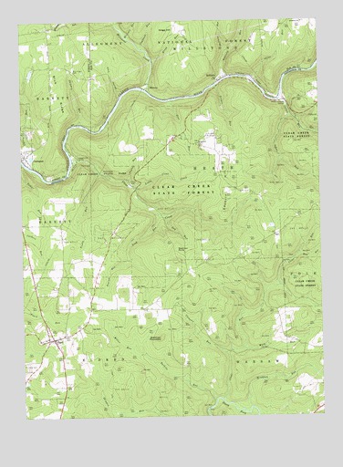
Sigel, PA USGS Topographic Map
Click on map above to begin viewing in our Map Viewer.

This topographic map contains these locations and features:
Feature Name Type Latitude Longitude GNIS ID View Map
Beartown RocksLocaleN41.3026°W79.0598°1214220View Map
Beartown RocksSummitN41.3034°W79.0595°1209406View Map
Beartown Rocks VistaLocaleN41.3026°W79.0525°1210368View Map
BelltownPopulated PlaceN41.3567°W79.0414°1209412View Map
Blue RidgeRidgeN41.3459°W79.1059°1209434View Map
Blue Ridge CemeteryCemeteryN41.3592°W79.1024°1209435View Map
Callen RunStreamN41.3503°W79.0150°1209471View Map
CCC Camp (historical)LocaleN41.3317°W79.0998°1210310View Map
ClaringtonPopulated PlaceN41.3326°W79.1231°1209504View Map
Clear CreekStreamN41.3295°W79.1034°1209505View Map
Clear CreekLocaleN41.3223°W79.0764°1213442View Map
Clear Creek State ForestForestN41.3206°W79.0561°1210184View Map
Clear Creek State ParkParkN41.3290°W79.0914°1209506View Map
Clear RunStreamN41.2556°W79.0417°1209507View Map
Clemens RunStreamN41.2698°W79.0389°1209508View Map
Cline RunStreamN41.3573°W79.0270°1209510View Map
Coalbank RunStreamN41.3662°W79.0736°1209513View Map
Dark HollowValleyN41.3522°W79.0824°1209545View Map
Dice RunStreamN41.3009°W79.0086°1209561View Map
Donathey ChurchChurchN41.3745°W79.0064°1209567View Map
Dry RunStreamN41.3137°W79.0645°1209570View Map
East Branch Millstone CreekStreamN41.3740°W79.0845°1210168View Map
Edeburn ChurchChurchN41.3367°W79.0489°1209589View Map
Edeburn HillSummitN41.3153°W79.0384°1209590View Map
English RunStreamN41.3006°W79.0798°1209596View Map
Gregg HillSummitN41.3712°W79.0600°1209644View Map
Gregg RunStreamN41.3634°W79.0681°1209645View Map
Heath Pumping StationLocaleN41.3490°W79.0131°1209664View Map
Hemlock TrailTrailN41.3426°W79.0620°1210366View Map
Hoffman RunStreamN41.3648°W79.0375°1209675View Map
Jefferson County Gas Company Pumping StationBuildingN41.3067°W79.0864°1210414View Map
Johns RunStreamN41.3448°W79.0114°1209711View Map
Leech SchoolSchoolN41.2845°W79.0856°1210309View Map
Leeper RunStreamN41.3545°W79.0423°1209751View Map
Little Clear CreekStreamN41.3220°W79.0770°1209763View Map
Little Clear Creek TrailTrailN41.3298°W79.0595°1210362View Map
Miller RunStreamN41.2720°W79.0786°1209822View Map
MillstonePopulated PlaceN41.3542°W79.0720°1209823View Map
Millstone CreekStreamN41.3537°W79.0714°1209824View Map
Mount Tabor CemeteryCemeteryN41.2656°W79.1231°1209836View Map
Oak Ridge TrailTrailN41.3265°W79.0617°1210363View Map
Phyllis RunStreamN41.3245°W79.0798°1209883View Map
Pine RunStreamN41.3501°W79.0598°1209891View Map
Pine Run TrailTrailN41.3442°W79.0589°1210367View Map
Shippen RunStreamN41.3426°W79.0992°1209978View Map
Shippen SchoolSchoolN41.3603°W79.1075°1210312View Map
SigelPopulated PlaceN41.2751°W79.1131°1211954View Map
Sigel Post OfficePost OfficeN41.2747°W79.1127°2779573View Map
Sigel Volunteer Fire Department Station 14BuildingN41.2788°W79.0982°2645544View Map
Silvis TrailTrailN41.3162°W79.0525°1210364View Map
Stahlman RoundtopSummitN41.2751°W79.0664°1210213View Map
Tadler RunStreamN41.3303°W79.1245°1210027View Map
Tarkiln RunStreamN41.2545°W79.0445°1210031View Map
Township of HeathCivilN41.3323°W79.0190°1216561View Map
Trap RunStreamN41.3140°W79.0675°1210057View Map
Truby RunStreamN41.3273°W79.0923°1210059View Map
Truman PondReservoirN41.2702°W79.1121°1210308View Map
United Gas Company Pumping StationBuildingN41.2937°W79.1200°1210415View Map
Wagon Box TrailTrailN41.3440°W79.0656°1210365View Map
Wallace SchoolSchoolN41.3353°W79.0481°1210311View Map
West Branch Millstone CreekStreamN41.3740°W79.0845°1217461View Map
Windfall RunStreamN41.2528°W79.0292°1210126View Map
Winlack RunStreamN41.3698°W79.0800°1210129View Map
Work RunStreamN41.2717°W79.0323°1210139View Map
Wyncoop RunStreamN41.3573°W79.0375°1210140View Map

Note: Coordinates in the location and feature list above are referenced to NAD83 datum.


Copyright (C) 2008-2025 Ryan Niemi / Sunset Dynamics ... All Rights Reserved