TopoQuest Logo
Do you find TopoQuest useful?
Help keep TopoQuest running and adding new maps/features by donating!
Bitcoin:  19c7KJd3qBynnjoSw5npx9KScwjBe4ifkT
Litecoin:  LXs6TkuXGGXo1vDsWCkWVdjQX94eUKd6ui
Home View Maps Find Maps Find Places Resources & Links


Bluffton, Indiana Topographic Map

USGS Map Title: Bluffton, IN
USGS Map MRC: 40085F2
DRG (GeoTIFF) Download: o40085f2.tif


Neighboring USGS Topographic Map Quads:


  Markle, IN  
40085G3
 

  Uniondale, IN  
40085G2
 

  Preble, IN  
40085G1
 

  Liberty Center, IN  
40085F3
 

  Bluffton, IN  
40085F2
 

  Linn Grove, IN  
40085F1
 

  Montpelier, IN  
40085E3
 

  Petroleum, IN  
40085E2
 

  Domestic, IN  
40085E1


Map MRC Location:

N41°
W86°
N41°
W85°
H8 H7 H6 H5 H4 H3 H2 H1
G8 G7 G6 G5 G4 G3 G2 G1
F8 F7 F6 F5 F4 F3 F2 F1
E8 E7 E6 E5 E4 E3 E2 E1
D8 D7 D6 D5 D4 D3 D2 D1
C8 C7 C6 C5 C4 C3 C2 C1
B8 B7 B6 B5 B4 B3 B2 B1
A8 A7 A6 A5 A4 A3 A2 A1
N40°
W86°
N40°
W85°

Bluffton, IN USGS 1:24K Topographic Map Preview:
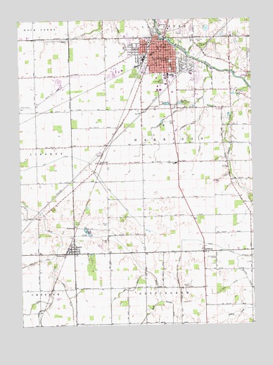
Bluffton, IN USGS Topographic Map
Click on map above to begin viewing in our Map Viewer.

This topographic map contains these locations and features:
Feature Name Type Latitude Longitude GNIS ID View Map
4-H ParkParkN40.7248°W85.1736°434722View Map
Allen SchoolSchoolN40.7356°W85.1783°430094View Map
Bethel ChurchChurchN40.6995°W85.1358°430943View Map
BlufftonPopulated PlaceN40.7387°W85.1716°431264View Map
Bluffton Fire DepartmentBuildingN40.7394°W85.1699°2625685View Map
Bluffton Police DepartmentBuildingN40.7396°W85.1697°2758227View Map
Bluffton Regional Medical CenterHospitalN40.7373°W85.1710°2660433View Map
Boyer DitchCanalN40.6845°W85.1427°431427View Map
Brinnemans Headacres Airport (historical)AirportN40.6362°W85.2322°449312View Map
Central SchoolSchoolN40.7384°W85.1772°432371View Map
City of BlufftonCivilN40.7425°W85.1731°2394209View Map
Columbian Elementary SchoolSchoolN40.7392°W85.1864°432825View Map
Craven DitchCanalN40.7070°W85.1597°433094View Map
Crosbie DitchCanalN40.7087°W85.1725°433174View Map
Delong DitchCanalN40.7156°W85.1719°433459View Map
East Side Elementary SchoolSchoolN40.7275°W85.1575°447512View Map
Elm CreekStreamN40.6623°W85.2286°434118View Map
Elm Grove CemeteryCemeteryN40.7417°W85.1535°434119View Map
Fairview CemeteryCemeteryN40.7436°W85.1626°434286View Map
Grannand CemeteryCemeteryN40.6528°W85.1458°435314View Map
GreenvillePopulated PlaceN40.6545°W85.2264°435457View Map
Grove CemeteryCemeteryN40.6669°W85.2035°435526View Map
Irvin DitchCanalN40.6278°W85.2500°436835View Map
Jefferson ParkParkN40.7303°W85.1686°436966View Map
Johns CreekStreamN40.6531°W85.1258°437025View Map
Johns DitchCanalN40.6600°W85.1575°437026View Map
Johnson DitchCanalN40.7425°W85.1958°437055View Map
King DitchCanalN40.6412°W85.1375°437325View Map
Lambert DitchCanalN40.6323°W85.2227°437580View Map
Lee Number Two DitchCanalN40.6373°W85.1983°437738View Map
Maddux-Showalter DitchCanalN40.6264°W85.2402°438467View Map
Markley DitchCanalN40.7217°W85.1502°438630View Map
McFarren CemeteryCemeteryN40.6736°W85.2475°438866View Map
Miller AirportAirportN40.7132°W85.2498°2677016View Map
Old Bluffton CemeteryCemeteryN40.7456°W85.1758°440541View Map
Old Columbian SchoolSchoolN40.7392°W85.1827°440553View Map
Park SchoolSchoolN40.7339°W85.1694°440880View Map
PonetoPopulated PlaceN40.6570°W85.2216°441431View Map
Poneto Volunteer Fire DepartmentBuildingN40.6549°W85.2216°2626146View Map
Popejoy DitchCanalN40.7025°W85.1530°441438View Map
Popular Grove SchoolSchoolN40.6917°W85.1661°441454View Map
Prairie ChurchChurchN40.6920°W85.1889°441538View Map
ReiffsburgPopulated PlaceN40.6559°W85.1519°449715View Map
Sixmile ChurchChurchN40.7200°W85.1314°443563View Map
Sixmile CreekStreamN40.7225°W85.1261°443564View Map
Stahl CemeteryCemeteryN40.6414°W85.1605°444048View Map
Town of PonetoCivilN40.6568°W85.2224°2396862View Map
Township of HarrisonCivilN40.6988°W85.1460°453400View Map
TravisvillePopulated PlaceN40.6920°W85.2080°444860View Map
Washington ParkParkN40.7334°W85.1683°445502View Map
WCRD-FM (Bluffton)TowerN40.7398°W85.1736°448993View Map
Wells CountyCivilN40.7292°W85.2212°450337View Map
Wells County Emergency Medical Services - Bluffton StationBuildingN40.7280°W85.1723°2719388View Map
Wells County Sheriff's OfficeBuildingN40.7336°W85.1946°2758048View Map
WellsburgPopulated PlaceN40.6662°W85.2216°445670View Map

Note: Coordinates in the location and feature list above are referenced to NAD83 datum.


Copyright (C) 2008-2025 Ryan Niemi / Sunset Dynamics ... All Rights Reserved