TopoQuest Logo
Do you find TopoQuest useful?
Help keep TopoQuest running and adding new maps/features by donating!
Bitcoin:  19c7KJd3qBynnjoSw5npx9KScwjBe4ifkT
Litecoin:  LXs6TkuXGGXo1vDsWCkWVdjQX94eUKd6ui
Home View Maps Find Maps Find Places Resources & Links


Burlington, Indiana Topographic Map

USGS Map Title: Burlington, IN
USGS Map MRC: 40086D4
DRG (GeoTIFF) Download: o40086d4.tif


Neighboring USGS Topographic Map Quads:


  Flora, IN  
40086E5
 

  Deer Creek, IN  
40086E4
 

  Young America, IN  
40086E3
 

  Rossville, IN  
40086D5
 

  Burlington, IN  
40086D4
 

  Russiaville, IN  
40086D3
 

  Frankfort, IN  
40086C5
 

  Michigantown, IN  
40086C4
 

  Hillisburg, IN  
40086C3


Map MRC Location:

N41°
W87°
N41°
W86°
H8 H7 H6 H5 H4 H3 H2 H1
G8 G7 G6 G5 G4 G3 G2 G1
F8 F7 F6 F5 F4 F3 F2 F1
E8 E7 E6 E5 E4 E3 E2 E1
D8 D7 D6 D5 D4 D3 D2 D1
C8 C7 C6 C5 C4 C3 C2 C1
B8 B7 B6 B5 B4 B3 B2 B1
A8 A7 A6 A5 A4 A3 A2 A1
N40°
W87°
N40°
W86°

Burlington, IN USGS 1:24K Topographic Map Preview:
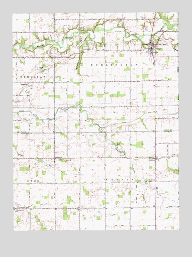
Burlington, IN USGS Topographic Map
Click on map above to begin viewing in our Map Viewer.

This topographic map contains these locations and features:
Feature Name Type Latitude Longitude GNIS ID View Map
Asbury CemeteryCemeteryN40.4913°W86.4489°430293View Map
Biery DitchCanalN40.3878°W86.4447°431009View Map
Boll Hill ChurchChurchN40.4678°W86.4783°431307View Map
BurlingtonPopulated PlaceN40.4803°W86.3947°431841View Map
Burlington CemeteryCemeteryN40.4814°W86.3970°431843View Map
Burlington Fire DepartmentBuildingN40.4797°W86.3957°2625723View Map
Campbell CemeteryCemeteryN40.3955°W86.3915°432080View Map
Carroll County Emergency Medical ServicesBuildingN40.4800°W86.3959°2719439View Map
GeetingsvillePopulated PlaceN40.4164°W86.4686°435475View Map
Grays CemeteryCemeteryN40.4185°W86.4165°435372View Map
Harness DitchCanalN40.4411°W86.3842°435757View Map
Hurricane CreekStreamN40.4861°W86.4422°436645View Map
Hye Park CemeteryCemeteryN40.4313°W86.4680°436670View Map
Koro ChurchChurchN40.4453°W86.4308°437443View Map
Lemert Airport (historical)AirportN40.4581°W86.3819°449358View Map
LexingtonPopulated PlaceN40.4589°W86.4889°437810View Map
MiddleforkPopulated PlaceN40.4156°W86.3925°449695View Map
Old Chaney CemeteryCemeteryN40.3872°W86.4972°440550View Map
Scofield DitchCanalN40.4514°W86.4917°440324View Map
Shaffer Stock FarmsLocaleN40.4369°W86.4453°2635313View Map
Sims CemeteryCemeteryN40.4092°W86.3803°443540View Map
Town of BurlingtonCivilN40.4808°W86.3943°2396619View Map
Township of BurlingtonCivilN40.4746°W86.4220°453146View Map
Township of WarrenCivilN40.3953°W86.4125°453974View Map
Whiteman DitchCanalN40.3939°W86.3886°445974View Map
WSHW-FM (Frankfort)TowerN40.4206°W86.4131°448998View Map

Note: Coordinates in the location and feature list above are referenced to NAD83 datum.


Copyright (C) 2008-2024 Ryan Niemi / Sunset Dynamics ... All Rights Reserved